Ethnographic routes: The rout of water
The climate of Valleseco is influenced by the Trade Winds and it is affected by the clouds and low pressures which come from the north. In spring, about 148,1 mm. of water falls, 17,1 mm in summer, 223,2 mm in autumn and 336,1 mm. in winter. After the conquest of the island, a lot of water channels were built to transport that water. In those days, the land and water of Valleseco were shared among foreign owners. Agriculture was the base of survival and water had a great value. For all these reasons, many infrastructures were created to take advantage of those resources.
Water channels, water tanks, wells, springs, fountains, washing areas were built to transport and use water. There was no public supply in houses and they needed the water fot the animals and crops. All these structures can be seen everywhere following the water channels and paths.
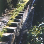
Water channels were used to transport this resource from wells, tunnels or reservoirs situated in the mountains to the fields, storage tanks or fountains for the population. Nowadays, they are still used for the same purpose.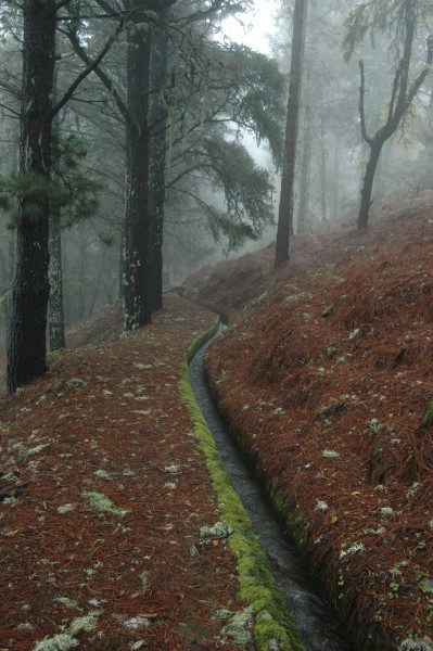
There are four main water channels in our municipality:
-
The water channel of Acequia Honda, was created in the first part of the XIX century by the Heredad de Aguas de Arucas y Firgas. They collect running water from the Andén and La Virgen ravines and take it to Arucas and Firgas.
-
The water channel of Acequia de la Cumbre, was built at the beginning of the XIX century. It takes the water from la Cumbre reservoir, near Roque Nublo,to Arucas.
-
The water channel of Acequia de Crespo, was mentioned in a document of 1893 where D. Cristóbal Manrique de Lara y Conte asked for permission to pass this water channel from the tunnels of his property to the municipality of Teror.
-
The water channel of Acequia de Romero, was built in XIX century and begins in the tank of El Ovejelillo, where the water of the Meleros spring is collected, and continues down to Teror and Arucas.
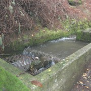
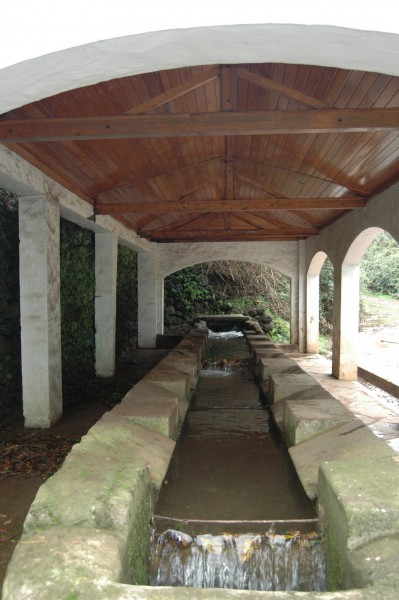
 Washing areas were situated along these water channels in the most populated areas and they were a great improvement, because before women had to go to the ravines to wash their clothes. They were built at the end of the XIX century and the beginning of the XX century. Some of them have four sided tiled roofs in order to protect women from the sun and the rain, such as those you can see in Zamora and Lanzarote. These washing areas are a typical image of Valleseco and many of them are still in use. They were a meeting point for women. There, they talked about the latest events and people brought them produce to be sold there, such as herbs, croquery, fish, etc. In Valleseco, 49 washing areas have been cataloged. Normally, women took a while to do the washing. First of all, they separated the clothes by colour, type and dirt. They soaked, soaped and beat them on stones and after a while they repeated the process. After that, they put the clothes over stones and bushes in the sun and sprinkled them with water to eliminate the stains. Sometines, if it was necessary, they repeated this process a third time or put the white clothes in water with indigo to improve the final result. Finally, they rang the clothing and hung it on lines or put it in containers to be taken home. 72% of the 215 washing areas of the island are situated in the municipalities of the North of Gran Canaria and the low area of Arucas. Valleseco has 49 and is the second village with more elements, after Arucas with 53, Nevertheless, Valleseco is the municipality where the tradition of using these washing areas has been preserved better. The neihbourhoods with more density of these elements are Valsendero with 15 units, Lanzarote with 16 and the center of Valleseco with 6.
“Cantoneras” are typical Canarian infrastructures. They were used to share water among commoners, farmers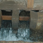 and field owners. Their origin was dated at the end of the Castilian conquest, when the land of the island was shared among the conquerors. They had fields on the coast and brought water for those crops from the interior of the island. They built water channels to transport it and had to ask for permission to pass them through the fields of other owners. In return, those propietors received a certain quantity of water for their own use. It was measured with these “cantoneras” which used very precise “tablillas” (pieces of woof of a certain size which let a certain quantity of water passed through).
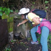 Fountains were built at the beginning of the XX century to make the water supply easier for the population. They normally had two small tanks: one for people and the other for animals. With a jar they collected water from the tank and put it into a container which they used to transport it. This water could come from a natural spring or tank. We can find some fountains in Carpinteras, Fuente del Junco, Fuente del Pilón; in Caserón, Fuente de Caserón; and in Zamora, Fuente de Zamora.
“Pilares” were another type of fountains. They were built in the fifties. They were situated along the course of the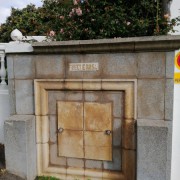 water channels. Water was diverted from the main channel to the “pilar”, where people could fill containers. They were put nearer to the population. Moreover, “pilares” were covered with tiles, which made them more higienic and water was cleaner because there was a tap instead of a tank. Some “pilares” situated in the neighbourhoods obtained water from natural springs, such as the Pilar in Calle Los Matos and that in Calle Flor de Mayo in the center of Valleseco; the “pilares” in Valsendero and those in Madrelagua.
Mills were set in the streams, because it was neccesary to move the mechanism 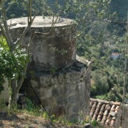 which turned the mill stones which ground the grain. Those mills were used to grind the grain and produce flour or gofio for human consumption. The miller ground the cereal in exchange for a part of the crop (“la maquila”) or money. In Valleseco, mills were used to grind maize to produce gofio and they were built in the second part of the XX century berween 1874 and 1900. There were 4 mills (Molino de Huerta Grande o Valsendero, Molino Chico, Molino del Molinete, Molino de Abajo) and one more in the border between Valleseco and Firgas (Molino de Cha Margarita). Three of them were situated in the course of the water channel belonging to the Heredad de aguas de Arucas and Firgas and next to the paths. Some of them also had a grocery shop. Nowadays, two of these mills have been restored, although some remains of the other two mills can be seen, such as the mill bucket .
Other infrastructures are:
 “Nateros o decantadores” (filters) were put in the course of the water channels to filter the water from leaves and soil and avoid obstructions in the water channels, specially when they went under the ground. Acueducts were used to avoid obstacles or differences of height in the course of the water channels, because water moved thanks to an slight inclination.
“Bebederos” (drinkers) were set in the course of the water channels in order that cattle could drink.
There are examples of these infrastructures in the main water channels. Other elements related to the water supply are wills, tanks, tanks in caves, ponds, cisterns and tunnels which are distributed around Valleseco.
To know all these ethnographic elements built to transport and use water, we have prepared two routes:
-THE WATER ROUTE: ACEQUIA HONDA
Circular walking tour of 8.56 kms. where you can observe a great part of this heritage situated in this water channel. It starts in Valsendero, Barranco de La Virgen, and climbs up to the road GC 307 and descends to the area of Caserón and El Molinete. From there, the path goes down to the Barranco de La Virgen again. Following the road you arrive to the starting point, in Valsendero. At this point, you have the option of going down to Las Madres and see some interesting elements of this water channel.
Recommendations: in some parts you have to walk along the road, so it is necessary to pay attention to the traffic. It is not advisable to follow the whole route along the water channel, because some parts are dangerous because of heights. For this reason, only the elements situated near the suggested route can be visited.
-THE WATER ROUTE: ACEQUIA DE CRESPO Y ACEQUIA DE LA CUMBRE (complete route)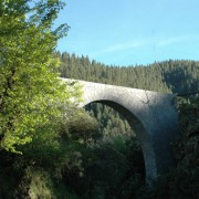
Circular rout of 12.77 kms. where you can follow part of the course of the water channels of Acequia de la Cumbre and Acequia de Crespo. You can see many elements of the heritage related to water transportation. This route starts is in the neighbourhood of El Lomo, passing by Lomo de la Rosa, Balcón de Zamora and La Laguna. From there, you can return to the center of Valleseco, Lanzarote, El Prado, Calderetas, Cueva Corcho and El Lomo. Although it is a circular route, you can start in any point of the path.
Recommendations: in some tramos you have to walk along the road, so it is necessary to pay attention to the traffic. It is not advisable to follow the whole route along the water channel, because there is danger of falling down from heights in some parts. For this reason, only the elements situated near the suggested route can be visited.
-THE WATER ROUTE: ACEQUIA DE CRESPO Y ACEQUIA DE LA CUMBRE (short route)
Circular route of 5.8 kms. Where you walk along part of the water channels of Acequia de la Cumbre and Acequia de Crespo. The starting point of the path is Lanzarote and after that you have to go down Lomo de la Rosa to find Balcón de Zamora. There, you have to go up again to the center of Valleseco and Lanzarote.
If you want to walk a bit further you can continue from Lanzarote to Cueva Corcho to visit some ethnographic elements in this place and return aong the same path
Recommendations: in some tramos you have to walk along the road, so it is necessary to pay attention to the traffic. It is not advisable to follow the whole route along the water channel, because there is danger of falling down from heights in some parts. For this reason, only the elements situated near the suggested route can be visited.
